
Haz una donación
Mapa topográfico Clark County
Haga clic en el mapa para ver la altitud.
Haz una donación
Clark County
Many lakes border the river in the lowlands near Ridgefield, including Vancouver Lake. Eastern and northern Clark County contain forested foothills of the Cascade Mountains, rising to an elevation of 4,000 feet (1,200 m) on the border with Skamania County. Larch Mountain is the county's highest free-standing peak.
Haz una donación
Acerca de este mapa
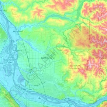
Nombre: Mapa topográfico Clark County, altitud, relieve.
Lugar: Clark County, Washington, United States (45.54373 -122.79596 46.05972 -122.24453)
Altitud media: 266 m
Altitud mínima: -3 m
Altitud máxima: 1 318 m
Haz una donación
Otros mapas topográficos
Haga clic en un mapa para ver su topografía, su altitud y su relieve.
Ellensburg
United States > Washington > Kittitas County > Ellensburg > Ellensburg
Altitud media: 485 m
Waterfront Park
United States > Washington > Clark County > Vancouver
A 12-foot (3.7 m) stone and bronze structure called Headwaters (or sometimes the Headwaters Wall) designed by artist Larry Kirkland was installed at Waterfront Park in August 2019. It is an interactive water feature that cost $3.5 million to construct. Headwaters features a cast bronze bas relief map of the…
Altitud media: 13 m
Stevens Pass
United States > Washington > King County
Stevens Pass (elevation 4,061 ft (1,238 m)) is a mountain pass through the Cascade Mountains located at the border of King County and Chelan County in Washington, United States. U.S. Route 2 travels over the pass, reaching a maximum elevation of 4,061 feet (1,238 m). The Pacific Crest Trail crosses the highway…
Altitud media: 1 387 m
Haz una donación
Haz una donación
Haz una donación
Snoqualmie Pass
United States > Washington > King County
Due to its elevation, Snoqualmie Pass experiences significantly lower temperatures than Seattle, and receives much more precipitation, much of it being snow. Snoqualmie Pass has a humid continental climate (Koppen: Dsb bordering Csb) with cold, very wet and snowy winters, and mild to warm, relatively dry…
Altitud media: 1 048 m
Haz una donación
Haz una donación
Haz una donación
Haz una donación
Haz una donación
Haz una donación
Mercer Island
United States > Washington > King County > Mercer Island
Mercer Island City Hall is located at 47°34′39″N 122°12′43.2″W / 47.57750°N 122.212000°W / 47.57750; -122.212000 (47.5775, -122.212). The peak elevation in the city is about 338 feet (103 m), near the center of the island.
Altitud media: 39 m
Haz una donación
Haz una donación
Haz una donación
Haz una donación
Haz una donación
Upper Salmon Junction
United States > Washington > Pacific County > Upper Salmon Junction
Altitud media: 89 m
Haz una donación