
Haz una donación
Mapa topográfico Four Brothers
Haga clic en el mapa para ver la altitud.
Haz una donación
Acerca de este mapa
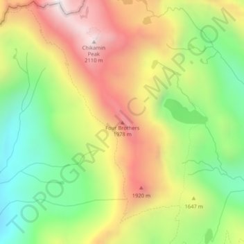
Nombre: Mapa topográfico Four Brothers, altitud, relieve.
Lugar: Four Brothers, Kittitas County, Washington, United States (47.46645 -121.30626 47.46655 -121.30616)
Altitud media: 1 577 m
Altitud mínima: 1 117 m
Altitud máxima: 2 095 m
Haz una donación
Otros mapas topográficos
Haga clic en un mapa para ver su topografía, su altitud y su relieve.
Kachess Lake
United States > Washington > Kittitas County
The lake is used as a storage reservoir for the Yakima Project, an irrigation project run by the United States Bureau of Reclamation. Although a natural lake, Kachess Lake's capacity and discharge is controlled by Kachess Dam, a 115-foot (35 m) high earthfill structure built in 1912. The discharge channel for…
Altitud media: 1 090 m
Keechelus Lake
United States > Washington > Kittitas County
Keechelus Lake is the westernmost of three large lakes near Interstate 90 and north of the Yakima River in the Cascade Range; the other two are Kachess Lake in the middle and Cle Elum Lake to the east. After crossing nearby Snoqualmie Pass at an elevation of 3,020 feet (920 m), Interstate 90 runs along the…
Altitud media: 1 024 m
Snoqualmie Pass
United States > Washington > Kittitas County
Due to its elevation, Snoqualmie Pass experiences significantly lower temperatures than Seattle, and receives much more precipitation, much of it being snow. Snoqualmie Pass has a humid continental climate (Koppen: Dsb bordering Csb) with cold, very wet and snowy winters, and mild to warm, relatively dry…
Altitud media: 955 m
Haz una donación