
Gracias por apoyar a este sitio ❤️
Haz una donación
Haz una donación
Mapa topográfico Mead
Haga clic en el mapa para ver la altitud.
Gracias por apoyar a este sitio ❤️
Haz una donación
Haz una donación
Acerca de este mapa
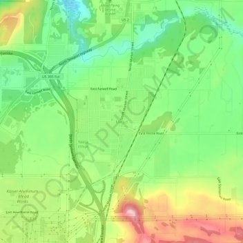
Nombre: Mapa topográfico Mead, altitud, relieve.
Lugar: Mead, Spokane County, Washington, 99021, United States (47.74739 -117.37494 47.78739 -117.33494)
Altitud media: 585 m
Altitud mínima: 511 m
Altitud máxima: 690 m
Gracias por apoyar a este sitio ❤️
Haz una donación
Haz una donación
Otros mapas topográficos
Haga clic en un mapa para ver su topografía, su altitud y su relieve.
Airway Heights
United States > Washington > Spokane County
The community lies in the northeastern corner of the flat Columbia Plateau. While the plateau tends to be flat, the terrain locally is quite rugged as it is part of the Channeled Scablands. The "heights" in the city's name references its location at a higher elevation than the city center of Spokane. Traveling…
Altitud media: 724 m