
Haz una donación
Mapa topográfico Grotto
Haga clic en el mapa para ver la altitud.
Haz una donación
Acerca de este mapa
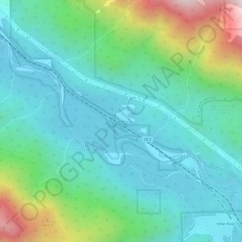
Nombre: Mapa topográfico Grotto, altitud, relieve.
Lugar: Grotto, King County, Washington, 98224, United States (47.71597 -121.44509 47.75597 -121.40509)
Altitud media: 528 m
Altitud mínima: 237 m
Altitud máxima: 1 474 m
Haz una donación
Otros mapas topográficos
Haga clic en un mapa para ver su topografía, su altitud y su relieve.
Kirkland
United States > Washington > King County
According to the United States Census Bureau, the city has a total area of 17.83 square miles (46.18 km2), of which 17.818 square miles (46.15 km2) are land and 0.012 square miles (0.03 km2) are water. The elevation varies from 14 to 500 feet (150 m) above sea level.
Altitud media: 55 m
Chester Morse Lake
United States > Washington > King County
Chester Morse Lake (originally Cedar Lake) is a lake in the upper region of the Cedar River watershed in the U.S. state of Washington. The original lake surface was 1,530 feet (466 m) above sea level, but when the river was dammed in 1900, the elevation was raised to 1,560 feet (475 m). Chester Morse Lake is…
Altitud media: 735 m
Haz una donación
Haz una donación
Mercer Island
United States > Washington > King County > Mercer Island
Mercer Island City Hall is located at 47°34′39″N 122°12′43.2″W / 47.57750°N 122.212000°W / 47.57750; -122.212000 (47.5775, -122.212). The peak elevation in the city is about 338 feet (103 m), near the center of the island.
Altitud media: 39 m
Haz una donación
Haz una donación