
Gracias por apoyar a este sitio ❤️
Haz una donación
Haz una donación
Mapa topográfico Longmire
Haga clic en el mapa para ver la altitud.
Gracias por apoyar a este sitio ❤️
Haz una donación
Haz una donación
Acerca de este mapa
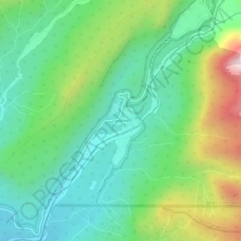
Nombre: Mapa topográfico Longmire, altitud, relieve.
Lugar: Longmire, Pierce County, Washington, United States (46.72954 -121.83254 46.76954 -121.79254)
Altitud media: 1 041 m
Altitud mínima: 735 m
Altitud máxima: 1 733 m
Gracias por apoyar a este sitio ❤️
Haz una donación
Haz una donación
Otros mapas topográficos
Haga clic en un mapa para ver su topografía, su altitud y su relieve.
Greenwater
United States > Washington > Pierce County
Greenwater is located at the confluence of the Greenwater and White Rivers, at an approximate elevation of 1,700 feet (520 m) above sea level.
Altitud media: 655 m
Gracias por apoyar a este sitio ❤️
Haz una donación
Haz una donación
Gracias por apoyar a este sitio ❤️
Haz una donación
Haz una donación