
Haz una donación
Mapa topográfico Okanogan
Haga clic en el mapa para ver la altitud.
Haz una donación
Acerca de este mapa
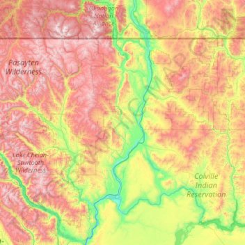
Nombre: Mapa topográfico Okanogan, altitud, relieve.
Lugar: Okanogan, Washington, United States (47.81585 -120.35275 49.21585 -118.95275)
Altitud media: 1 115 m
Altitud mínima: 217 m
Altitud máxima: 2 704 m
Haz una donación
Otros mapas topográficos
Haga clic en un mapa para ver su topografía, su altitud y su relieve.
Waterfront Park
United States > Washington > Clark County > Vancouver
A 12-foot (3.7 m) stone and bronze structure called Headwaters (or sometimes the Headwaters Wall) designed by artist Larry Kirkland was installed at Waterfront Park in August 2019. It is an interactive water feature that cost $3.5 million to construct. Headwaters features a cast bronze bas relief map of the…
Altitud media: 13 m
Haz una donación
Kachess Lake
United States > Washington > Kittitas County
The lake is used as a storage reservoir for the Yakima Project, an irrigation project run by the United States Bureau of Reclamation. Although a natural lake, Kachess Lake's capacity and discharge is controlled by Kachess Dam, a 115-foot (35 m) high earthfill structure built in 1912. The discharge channel for…
Altitud media: 1 090 m
Haz una donación
Haz una donación
Concrete
United States > Washington > Skagit County
Mears Field (3W5), formerly known as Concrete Municipal Airport, is located one mile south of Concrete at an elevation of 267 ft MSL.
Altitud media: 125 m
Haz una donación
Airway Heights
United States > Washington > Spokane County
The community lies in the northeastern corner of the flat Columbia Plateau. While the plateau tends to be flat, the terrain locally is quite rugged as it is part of the Channeled Scablands. The "heights" in the city's name references its location at a higher elevation than the city center of Spokane. Traveling…
Altitud media: 724 m
Kirkland
United States > Washington > King County
According to the United States Census Bureau, the city has a total area of 17.83 square miles (46.18 km2), of which 17.818 square miles (46.15 km2) are land and 0.012 square miles (0.03 km2) are water. The elevation varies from 14 to 500 feet (150 m) above sea level.
Altitud media: 55 m
Haz una donación
Haz una donación
Greenwater
United States > Washington > Pierce County
Greenwater is located at the confluence of the Greenwater and White Rivers, at an approximate elevation of 1,700 feet (520 m) above sea level.
Altitud media: 655 m
Haz una donación
Haz una donación
Keechelus Lake
United States > Washington > Kittitas County
Keechelus Lake is the westernmost of three large lakes near Interstate 90 and north of the Yakima River in the Cascade Range; the other two are Kachess Lake in the middle and Cle Elum Lake to the east. After crossing nearby Snoqualmie Pass at an elevation of 3,020 feet (920 m), Interstate 90 runs along the…
Altitud media: 1 024 m
Chester Morse Lake
United States > Washington > King County
Chester Morse Lake (originally Cedar Lake) is a lake in the upper region of the Cedar River watershed in the U.S. state of Washington. The original lake surface was 1,530 feet (466 m) above sea level, but when the river was dammed in 1900, the elevation was raised to 1,560 feet (475 m). Chester Morse Lake is…
Altitud media: 735 m
Haz una donación
Haz una donación
Haz una donación
William O. Douglas Wilderness
United States > Washington > Yakima County
While significant portions of the William O. Douglas Wilderness are high elevation forest, the overall topography is varied. The tallest and most visually striking peak is Mount Aix at 7,766 feet (2,367 m) with a prominence of 3,286 feet (1,002 m). The Cougar Lakes portion is characterized by high alpine…
Altitud media: 1 371 m
Haz una donación
Richland
United States > Washington > Benton County
According to the United States Census Bureau, the city has a total area of 39.11 square miles (101.29 km2), of which, 35.72 square miles (92.51 km2) is land and 3.39 square miles (8.78 km2) is water. Elevation at the airport is 120 m (390 ft).
Altitud media: 160 m
Haz una donación
Olympic National Park
Views of the Olympic National Park can be seen from the Hurricane Ridge viewpoint. The road leading west from the Hurricane Ridge visitor center has several picnic areas and trailheads. A paved trail called the Hurricane Hill trail is about 1.6 miles (2.6 km) long each way, with an elevation gain of about 700…
Altitud media: 412 m
Marysville
United States > Washington > Snohomish County
The city's topography varies from the low-lying downtown, located along the banks of Ebey Slough 5 feet (1.5 m) above sea level, rising to 160 feet (49 m) near Smokey Point and over 465 feet (142 m) in the eastern highlands. Marysville sits in the watershed of two major creeks, Quilceda Creek and Allen Creek,…
Altitud media: 72 m
Haz una donación
Snoqualmie Pass
United States > Washington > Kittitas County
Due to its elevation, Snoqualmie Pass experiences significantly lower temperatures than Seattle, and receives much more precipitation, much of it being snow. Snoqualmie Pass has a humid continental climate (Koppen: Dsb bordering Csb) with cold, very wet and snowy winters, and mild to warm, relatively dry…
Altitud media: 955 m
Carpenter Lake Nature Preserve
United States > Washington > Kitsap County > Kingston
Altitud media: 36 m
Haz una donación
Haz una donación
Mercer Island
United States > Washington > King County > Mercer Island
Mercer Island City Hall is located at 47°34′39″N 122°12′43.2″W / 47.57750°N 122.212000°W / 47.57750; -122.212000 (47.5775, -122.212). The peak elevation in the city is about 338 feet (103 m), near the center of the island.
Altitud media: 39 m
Kennewick
United States > Washington > Benton County
Native Americans populated the area around modern-day Kennewick for millennia before being discovered and settled by European descendants. These inhabitants consisted of people from the Umatilla, Wanapum, Nez Perce, and Yakama tribes. Kennewick's low elevation helped to moderate winter temperatures. On top of…
Altitud media: 154 m
Haz una donación
Haz una donación
Haz una donación
Clark County
Many lakes border the river in the lowlands near Ridgefield, including Vancouver Lake. Eastern and northern Clark County contain forested foothills of the Cascade Mountains, rising to an elevation of 4,000 feet (1,200 m) on the border with Skamania County. Larch Mountain is the county's highest free-standing…
Altitud media: 266 m
Haz una donación
Haz una donación
Haz una donación
Haz una donación