
Haz una donación
Mapa topográfico Marysville
Haga clic en el mapa para ver la altitud.
Haz una donación
Marysville
The city's topography varies from the low-lying downtown, located along the banks of Ebey Slough 5 feet (1.5 m) above sea level, rising to 160 feet (49 m) near Smokey Point and over 465 feet (142 m) in the eastern highlands. Marysville sits in the watershed of two major creeks, Quilceda Creek and Allen Creek, and approximately 70 minor streams that flow into Ebey Slough and Snohomish River. During the early 20th century, repeated controlled flooding and other engineering works in the Snohomish River delta contributed to the replenishment of the area's fertile silty soil for use in farming.
Haz una donación
Acerca de este mapa
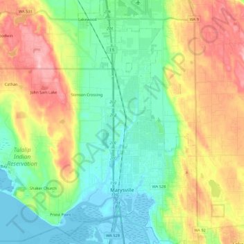
Nombre: Mapa topográfico Marysville, altitud, relieve.
Lugar: Marysville, Snohomish County, Washington, United States (48.01984 -122.28651 48.16329 -122.10961)
Altitud media: 72 m
Altitud mínima: -3 m
Altitud máxima: 201 m
Haz una donación
Otros mapas topográficos
Haga clic en un mapa para ver su topografía, su altitud y su relieve.