
Mapa topográfico Taarlo
Mapa interactivo
Haga clic en el mapa para ver la altitud.
Acerca de este mapa
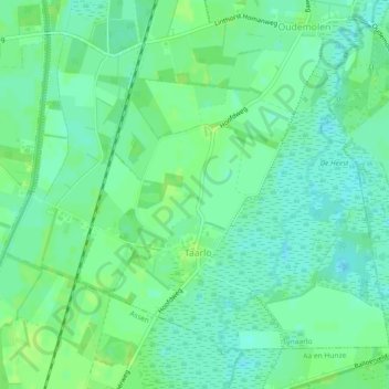
Nombre: Mapa topográfico Taarlo, altitud, relieve.
Lugar: Taarlo, Tynaarlo, Drenthe, Nederland (53.02578 6.60301 53.04843 6.64859)
Altitud media: 8 m
Altitud mínima: 2 m
Altitud máxima: 13 m
Otros mapas topográficos
Haga clic en un mapa para ver su topografía, su altitud y su relieve.
Oosterbroek
Oosterbroek, Eelde, Tynaarlo, Drenthe, Nederland, 9761 TG, Nederland
Altitud media: 3 m
Oosterhesselen
Nederland > Drenthe > Coevorden
Oosterhesselen, Coevorden, Drenthe, Nederland
Altitud media: 15 m
Nieuw-Buinen
Nederland > Drenthe > Nieuw-Buinen
Nieuw-Buinen, Borger-Odoorn, Drenthe, Nederland
Altitud media: 7 m