
Haz una donación
Mapa topográfico Hurley
Haga clic en el mapa para ver la altitud.
Haz una donación
Acerca de este mapa
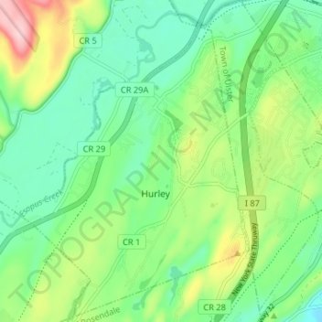
Nombre: Mapa topográfico Hurley, altitud, relieve.
Altitud media: 80 m
Altitud mínima: 18 m
Altitud máxima: 213 m
Haz una donación
Otros mapas topográficos
Haga clic en un mapa para ver su topografía, su altitud y su relieve.
Mohonk Mountain House Property
United States > New York > Ulster County > Town of New Paltz
Altitud media: 228 m
Haz una donación
Sojourner Truth State Park
United States > New York > Ulster County > City of Kingston > East Kingston
Altitud media: 38 m
Haz una donación
Haz una donación
Haz una donación
Big Indian Park
United States > New York > Ulster County > Town of Shandaken > Big Indian
Altitud media: 493 m
Bear Hill Preserve (Cragsmoor Free Library)
United States > New York > Ulster County > Town of Wawarsing > Cragsmoor
Altitud media: 414 m
Haz una donación
Sam's Point Overlook
United States > New York > Ulster County > Town of Wawarsing > Village of Ellenville
Altitud media: 542 m
Haz una donación
Haz una donación
Red Hill Fire Tower
United States > New York > Ulster County > Town of Denning
The cabin is a small, one-story, 14-by-24-foot (4.3 by 7.3 m) gable-roofed frame building. It is sided with "brainstorm", edge board stained reddish brown. It has a mortared rubblestone foundation and a covered porch on the south elevation, originally decked in wood but since replaced with concrete. Built in…
Altitud media: 713 m
Frost Valley
United States > New York > Ulster County > Town of Denning > Frost Valley
Altitud media: 735 m
Haz una donación