
Haz una donación
Mapa topográfico Winchell
Haga clic en el mapa para ver la altitud.
Haz una donación
Acerca de este mapa
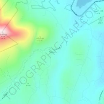
Nombre: Mapa topográfico Winchell, altitud, relieve.
Altitud media: 313 m
Altitud mínima: 176 m
Altitud máxima: 835 m
Haz una donación
Otros mapas topográficos
Haga clic en un mapa para ver su topografía, su altitud y su relieve.
Slide Mountain Wilderness
United States > New York > Ulster County > Town of Shandaken > Town of Denning
Within its boundaries lie 10 of the 35 Catskill High Peaks, including the highest Catskill peak, Slide, 4,180 feet (1277 m) of elevation; and lowest, Rocky.
Altitud media: 584 m
Mohonk Mountain House Property
United States > New York > Ulster County > Town of New Paltz
Altitud media: 228 m
Haz una donación
Sojourner Truth State Park
United States > New York > Ulster County > City of Kingston > East Kingston
Altitud media: 38 m
Haz una donación
Haz una donación
Big Indian Park
United States > New York > Ulster County > Town of Shandaken > Big Indian
Altitud media: 493 m
Haz una donación
Bear Hill Preserve (Cragsmoor Free Library)
United States > New York > Ulster County > Town of Wawarsing > Cragsmoor
Altitud media: 414 m
Haz una donación
Town of Shandaken
United States > New York > Ulster County
The town is inside the Catskill Park, and is entirely mountainous. Within it lies Slide Mountain, the Catskill Mountains' highest peak at 4,180 ft (1,270 m), and several of the other Catskill High Peaks over 3,500 ft (1,100 m) in elevation.
Altitud media: 652 m