
Gracias por apoyar a este sitio ❤️
Haz una donación
Haz una donación
Mapa topográfico Oliverea
Haga clic en el mapa para ver la altitud.
Gracias por apoyar a este sitio ❤️
Haz una donación
Haz una donación
Acerca de este mapa
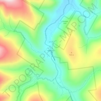
Nombre: Mapa topográfico Oliverea, altitud, relieve.
Altitud media: 591 m
Altitud mínima: 396 m
Altitud máxima: 917 m
Gracias por apoyar a este sitio ❤️
Haz una donación
Haz una donación
Otros mapas topográficos
Haga clic en un mapa para ver su topografía, su altitud y su relieve.
Slide Mountain Wilderness
United States > New York > Ulster County > Town of Shandaken > Town of Denning
Within its boundaries lie 10 of the 35 Catskill High Peaks, including the highest Catskill peak, Slide, 4,180 feet (1277 m) of elevation; and lowest, Rocky.
Altitud media: 584 m
Big Indian Park
United States > New York > Ulster County > Town of Shandaken > Big Indian
Altitud media: 493 m