
Mapa topográfico Gryon
Mapa interactivo
Haga clic en el mapa para ver la altitud.
Acerca de este mapa
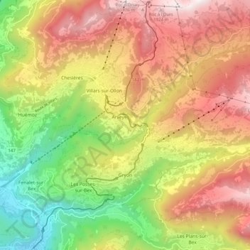
Nombre: Mapa topográfico Gryon, altitud, relieve.
Lugar: Gryon, District d'Aigle, Vaud, 1882, Switzerland (46.26606 7.05242 46.31035 7.15140)
Altitud media: 1 240 m
Altitud mínima: 457 m
Altitud máxima: 2 014 m
The municipality is located in the Aigle district, on a narrow terrace at an elevation of 1,110 m (3,640 ft) between the Gryonne and Avançon canyons. To the east lie the hillside settlements of Les Chaux and La Barboleusaz (or Barboleuse). In the north are forests and the alpine pasture of Taveyanne. The western border with Bex was established in 1676.
Otros mapas topográficos
Haga clic en un mapa para ver su topografía, su altitud y su relieve.
Drapel
Switzerland > Vaud > District d'Aigle > Aigle
Drapel, Aigle, District d'Aigle, Vaud, 1860, Switzerland
Altitud media: 716 m
Vallée du Rhône
Switzerland > Vaud > District d'Aigle
Vallée du Rhône, District d'Aigle, Vaud, Switzerland
Altitud media: 1 378 m
Leysin
Switzerland > Vaud > District d'Aigle
Leysin, District d'Aigle, Vaud, 1854, Switzerland
Altitud media: 1 352 m
Noville
Switzerland > Vaud > District d'Aigle
Noville, District d'Aigle, Vaud, 1845, Switzerland
Altitud media: 384 m
Glacier du Dar
Switzerland > Vaud > District d'Aigle > Ormont-Dessus
Glacier du Dar, Ormont-Dessus, District d'Aigle, Vaud, Switzerland
Altitud media: 2 554 m
Chambon
Switzerland > Vaud > District d'Aigle > Roche (VD)
Chambon, Roche (VD), District d'Aigle, Vaud, 1852, Switzerland
Altitud media: 485 m
Aigle
Switzerland > Vaud > District d'Aigle
Aigle, District d'Aigle, Vaud, 1860, Switzerland
Altitud media: 647 m