
Mapa topográfico Aigle
Mapa interactivo
Haga clic en el mapa para ver la altitud.
Acerca de este mapa
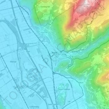
Nombre: Mapa topográfico Aigle, altitud, relieve.
Lugar: Aigle, District d'Aigle, Vaud, 1860, Switzerland (46.29131 6.93177 46.34167 7.04028)
Altitud media: 647 m
Altitud mínima: 371 m
Altitud máxima: 1 948 m
Aigle lies at an elevation of 415 m (1,362 ft) about 13 km (8.1 mi) south-southeast of Montreux. It is on the east edge of the Rhône valley, at the foot of the Swiss Alps.
Otros mapas topográficos
Haga clic en un mapa para ver su topografía, su altitud y su relieve.
Drapel
Switzerland > Vaud > District d'Aigle > Aigle
Drapel, Aigle, District d'Aigle, Vaud, 1860, Switzerland
Altitud media: 716 m
Vallée du Rhône
Switzerland > Vaud > District d'Aigle
Vallée du Rhône, District d'Aigle, Vaud, Switzerland
Altitud media: 1 378 m
Gryon
Switzerland > Vaud > District d'Aigle
Gryon, District d'Aigle, Vaud, 1882, Switzerland
Altitud media: 1 240 m
Leysin
Switzerland > Vaud > District d'Aigle
Leysin, District d'Aigle, Vaud, 1854, Switzerland
Altitud media: 1 352 m
Noville
Switzerland > Vaud > District d'Aigle
Noville, District d'Aigle, Vaud, 1845, Switzerland
Altitud media: 384 m
Glacier du Dar
Switzerland > Vaud > District d'Aigle > Ormont-Dessus
Glacier du Dar, Ormont-Dessus, District d'Aigle, Vaud, Switzerland
Altitud media: 2 554 m
Chambon
Switzerland > Vaud > District d'Aigle > Roche (VD)
Chambon, Roche (VD), District d'Aigle, Vaud, 1852, Switzerland
Altitud media: 485 m