
Mapa topográfico Leysin
Mapa interactivo
Haga clic en el mapa para ver la altitud.
Acerca de este mapa
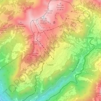
Nombre: Mapa topográfico Leysin, altitud, relieve.
Lugar: Leysin, District d'Aigle, Vaud, 1854, Switzerland (46.32070 6.97711 46.38518 7.04051)
Altitud media: 1 352 m
Altitud mínima: 415 m
Altitud máxima: 2 299 m
The municipality is located in the Aigle district, on the right side of the Grande-Eau at the foot of the Tour d'Aï and the Tour de Mayen. The main village is located at an elevation of 1,260 m (4,130 ft). It consists of the village of Leysin and the hamlets of Veyges, Feydey, Aï, and Mayen.
Otros mapas topográficos
Haga clic en un mapa para ver su topografía, su altitud y su relieve.
Drapel
Switzerland > Vaud > District d'Aigle > Aigle
Drapel, Aigle, District d'Aigle, Vaud, 1860, Switzerland
Altitud media: 716 m
Vallée du Rhône
Switzerland > Vaud > District d'Aigle
Vallée du Rhône, District d'Aigle, Vaud, Switzerland
Altitud media: 1 378 m
Gryon
Switzerland > Vaud > District d'Aigle
Gryon, District d'Aigle, Vaud, 1882, Switzerland
Altitud media: 1 240 m
Noville
Switzerland > Vaud > District d'Aigle
Noville, District d'Aigle, Vaud, 1845, Switzerland
Altitud media: 384 m
Glacier du Dar
Switzerland > Vaud > District d'Aigle > Ormont-Dessus
Glacier du Dar, Ormont-Dessus, District d'Aigle, Vaud, Switzerland
Altitud media: 2 554 m
Chambon
Switzerland > Vaud > District d'Aigle > Roche (VD)
Chambon, Roche (VD), District d'Aigle, Vaud, 1852, Switzerland
Altitud media: 485 m
Aigle
Switzerland > Vaud > District d'Aigle
Aigle, District d'Aigle, Vaud, 1860, Switzerland
Altitud media: 647 m