
Mapa topográfico Altdorf (UR)
Mapa interactivo
Haga clic en el mapa para ver la altitud.
Acerca de este mapa
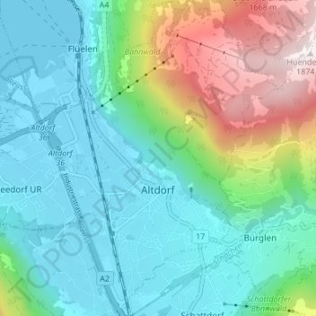
Nombre: Mapa topográfico Altdorf (UR), altitud, relieve.
Lugar: Altdorf (UR), Uri, 6460, Switzerland (46.86364 8.61551 46.90976 8.66732)
Altitud media: 796 m
Altitud mínima: 431 m
Altitud máxima: 1 859 m
The municipality covers an area of 10.21 square kilometres (3.94 sq mi). The town proper sits at an altitude of 458 metres (1,503 ft) above sea level on a flat alluvial plain between the right bank of the river Reuss and the steep hillside of the Rossstock 2.4 km (1.5 mi) to the east. The scattered hamlets and pasteumreland of Eggbergen, about 1,000 metres (3,300 ft) above the town, also belong to the municipality.
Otros mapas topográficos
Haga clic en un mapa para ver su topografía, su altitud y su relieve.
Hospental
Switzerland > Uri > Korporation Ursern
Hospental, Korporation Ursern, Uri, 6493, Switzerland
Altitud media: 2 144 m
Realp
Switzerland > Uri > Korporation Ursern
Realp, Korporation Ursern, Uri, 6491, Switzerland
Altitud media: 2 282 m
Klausenpass
Switzerland > Uri > Unterschächen
Klausenpass, Unterschächen, Uri, 6465, Switzerland
Altitud media: 2 103 m
Oberalp
Switzerland > Uri > Unterschächen
Oberalp, Unterschächen, Uri, 6465, Switzerland
Altitud media: 1 900 m
Sektor Spongebob
Switzerland > Uri > Wassen
Sektor Spongebob, Wassen, Uri, Switzerland
Altitud media: 2 189 m
Oberalppass
Switzerland > Uri > Korporation Ursern > Andermatt
Oberalppass, Andermatt, Korporation Ursern, Uri, 6490, Switzerland
Altitud media: 2 219 m
Glatten
Switzerland > Uri > Spiringen
Glatten, Spiringen, Uri, 8751, Switzerland
Altitud media: 2 090 m
Rhonegletscher
Switzerland > Uri > Korporation Ursern > Realp
Rhonegletscher, Realp, Korporation Ursern, Oberland administrative region, Uri, 6491, Switzerland
Altitud media: 2 802 m
Andermatt
Switzerland > Uri > Korporation Ursern
Andermatt, Korporation Ursern, Uri, 6490, Switzerland
Altitud media: 2 127 m