Geolocalizar

Mapa topográfico Andermatt

Mapa interactivo

Haga clic en el mapa para ver la altitud.

Acerca de este mapa

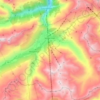
Nombre: Mapa topográfico Andermatt, altitud, relieve.

Lugar: Andermatt, Korporation Ursern, Uri, 6490, Switzerland (46.56410 8.54654 46.67706 8.68192)

Altitud media: 2 127 m

Altitud mínima: 1 023 m

Altitud máxima: 2 972 m

Andermatt (Romansh: Ursera (help·info)) is a mountain village and municipality in the canton of Uri in Switzerland. At an elevation of 1,437 meters (4,715 ft) above sea level, Andermatt is located at the center of the Saint-Gotthard Massif and the historical center cross of north-south and east-west traverses of Switzerland. It is some 28 km (17 mi) south of Altdorf, the capital of Uri.

Wikipedia (CC-BY-SA 3.0)

Otros mapas topográficos

Haga clic en un mapa para ver su topografía, su altitud y su relieve.

Hospental

Switzerland > Uri > Korporation Ursern

Hospental, Korporation Ursern, Uri, 6493, Switzerland

Altitud media: 2 144 m

Realp

Switzerland > Uri > Korporation Ursern

Realp, Korporation Ursern, Uri, 6491, Switzerland

Altitud media: 2 282 m

Oberalppass

Switzerland > Uri > Korporation Ursern > Andermatt

Oberalppass, Andermatt, Korporation Ursern, Uri, 6490, Switzerland

Altitud media: 2 219 m

Rhonegletscher

Switzerland > Uri > Korporation Ursern > Realp

Rhonegletscher, Realp, Korporation Ursern, Oberland administrative region, Uri, 6491, Switzerland

Altitud media: 2 802 m