
Mapa topográfico Schwander Grat
Mapa interactivo
Haga clic en el mapa para ver la altitud.
Acerca de este mapa
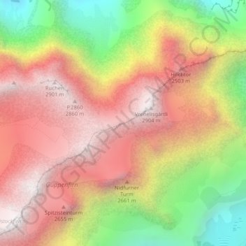
Nombre: Mapa topográfico Schwander Grat, altitud, relieve.
Lugar: Schwander Grat, Glarus Süd, Glarus, 8774, Switzerland (47.00529 9.00980 47.00665 9.01401)
Altitud media: 2 289 m
Altitud mínima: 1 452 m
Altitud máxima: 2 900 m
Otros mapas topográficos
Haga clic en un mapa para ver su topografía, su altitud y su relieve.
Braunwald
Switzerland > Glarus > Glarus Süd
Braunwald, Glarus Süd, Glarus, 8784, Switzerland
Altitud media: 1 215 m
Schwanden
Switzerland > Glarus > Glarus Süd
Schwanden, Glarus Süd, Glarus, 8762, Switzerland
Altitud media: 813 m
Mitlödi
Switzerland > Glarus > Glarus Süd > Mitlödi
Mitlödi, Glarus Süd, Glarus, 8756, Switzerland
Altitud media: 800 m