
Haz una donación
Mapa topográfico Somerset County
Haga clic en el mapa para ver la altitud.
Haz una donación
Somerset County
Somerset County along with Garrett County is one of the snowiest inhabited locations in the United States, with the highest elevations of the county averaging 150+ inches of snow each winter. The county's elevation and general proximity to both the Great Lakes and the Atlantic Ocean causes snow from both Nor'easters and lake effect upslope snow events to fall from late October through early April. Snow has been recorded in Somerset County in every month except July, although local lore has it that even July saw snow in 1816, "the year without a summer." Mount Davis, the highest natural point in the state of Pennsylvania at 3,213 feet (979 m), is located in the southern part of the county.
Haz una donación
Acerca de este mapa
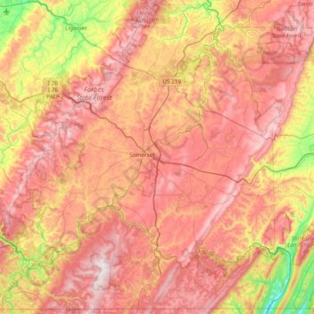
Nombre: Mapa topográfico Somerset County, altitud, relieve.
Lugar: Somerset County, Pennsylvania, United States (39.72142 -79.41778 40.28537 -78.65841)
Altitud media: 632 m
Altitud mínima: 221 m
Altitud máxima: 975 m
Haz una donación
Otros mapas topográficos
Haga clic en un mapa para ver su topografía, su altitud y su relieve.
Haz una donación
Blue Mountain
United States > Pennsylvania > Monroe County > Eldred Township
The ridge of Blue Mountain runs for 150 miles (240 km) through Pennsylvania, reaching an elevation of 2,270 feet (690 m) above sea level just north of the Pennsylvania Turnpike, near the borough of Newburg. Most of the ridgecrest, however, only reaches between 1,400 and 1,700 feet (430 and 520 m) in elevation.…
Altitud media: 242 m
Wimmers
United States > Pennsylvania > Lackawanna County > Jefferson Township > Mount Cobb
Altitud media: 495 m
Haz una donación
Breezewood
United States > Pennsylvania > Bedford County > East Providence Township
Altitud media: 413 m
Faylor Lake
United States > Pennsylvania > Snyder County > Spring Township > Beaver Springs
Altitud media: 197 m
Haz una donación
Mount Nebo Park
United States > Pennsylvania > Monroe County > East Stroudsburg > Twin Falls
Altitud media: 185 m
Haz una donación
Haz una donación
Haz una donación
New Enterprise
United States > Pennsylvania > Bedford County > South Woodbury Township
Altitud media: 397 m
Haz una donación
Blue Knob
United States > Pennsylvania > Bedford County > Pavia Township
Blue Knob (elevation 3,146 feet (959 m)) is a summit in the eastern United States with a broad dome that is the northernmost 3,000-footer in the Allegheny Mountains. It is the highest point in Bedford County, Pennsylvania.
Altitud media: 792 m
Saint Benedict
United States > Pennsylvania > Cambria County > West Carroll Township
Altitud media: 582 m
Haz una donación
Tyrrel Farm Corners
United States > Pennsylvania > Venango County > Allegheny Township
Altitud media: 478 m
Fort Hunter
United States > Pennsylvania > Dauphin County > Middle Paxton Township
Altitud media: 149 m
Haz una donación
Haz una donación
Three Tuns
United States > Pennsylvania > Montgomery County > Upper Dublin Township > Maple Glen
Altitud media: 101 m
Hidden Valley
United States > Pennsylvania > Montgomery County > Upper Merion Township
Altitud media: 47 m
Haz una donación
Haz una donación
Robinson
United States > Pennsylvania > Indiana County > West Wheatfield Township
Altitud media: 397 m
Fogelsville
United States > Pennsylvania > Lehigh County > Upper Macungie Township
Altitud media: 155 m
Haz una donación
Mount Bethel
United States > Pennsylvania > Northampton County > Upper Mount Bethel Township
Altitud media: 156 m
Haz una donación
Reservoir Heights
United States > Pennsylvania > Dauphin County > Upper Paxton Township
Altitud media: 189 m
Haz una donación
Skytop
United States > Pennsylvania > Monroe County > Barrett Township
Skytop is an unincorporated community in Barrett Township, Monroe County, Pennsylvania, United States. Located north of Mountainhome, it is accessible by local roads off Route 390. Its elevation is 1,562 feet (476 m), and it is located at 41°13′40″N 75°14′18″W / 41.22778°N 75.23833°W /…
Altitud media: 469 m
Ricketts Glen State Park
United States > Pennsylvania > Luzerne County > Fairmount Township
The state's original plans for the new park included building an inn, an 18-hole golf course and country club, and a winter sports complex for skiing, ice boating, and tobogganing, as well as a beach with bathing facilities, cabins, and a tent camping area. Only the last three were actually built, all south of…
Altitud media: 588 m
Haz una donación
Haz una donación
Portlamd Waterfront Park
United States > Pennsylvania > Northampton County > Portland
Altitud media: 118 m
Haz una donación
Stevens Point
United States > Pennsylvania > Susquehanna County > Harmony Township
Altitud media: 434 m
Pendle Hill
United States > Pennsylvania > Delaware County > Nether Providence Township
Altitud media: 61 m
Haz una donación
Longwood Gardens
United States > Pennsylvania > Chester County > East Marlborough Township
Altitud media: 125 m
Nottingham County Park
United States > Pennsylvania > Chester County > West Nottingham Township
Altitud media: 137 m
Marble Hall
United States > Pennsylvania > Montgomery County > Whitemarsh Township
Altitud media: 64 m
Haz una donación
Circleville
United States > Pennsylvania > Westmoreland County > North Huntingdon Township
Altitud media: 333 m
Haz una donación
Chadds Ford Township
United States > Pennsylvania > Delaware County > Chadds Ford Township
Altitud media: 101 m
Strawberry Mansion
United States > Pennsylvania > Philadelphia County > Philadelphia
Altitud media: 31 m
Reinholds
United States > Pennsylvania > Lancaster County > West Cocalico Township
Altitud media: 159 m
Haz una donación
Langhorne Gardens
United States > Pennsylvania > Bucks County > Middletown Township
Altitud media: 45 m
Haz una donación
Hanover Junction
United States > Pennsylvania > York County > North Codorus Township
Altitud media: 187 m
Champion
United States > Pennsylvania > Allegheny County > North Fayette Township
Altitud media: 360 m
Haz una donación
Fagleysville
United States > Pennsylvania > Montgomery County > New Hanover Township
Altitud media: 105 m
Lake Keystone
United States > Pennsylvania > Armstrong County > Plumcreek Township
Keystone Lake (also known as Keystone Reservoir and Plum Creek Reservoir) is a reservoir in Armstrong County in the U.S. state of Pennsylvania. The elevation of Keystone Lake is 1,076 feet (328 m) above sea level.
Altitud media: 357 m
Haz una donación