
Haz una donación
Mapa topográfico Strawberry Mansion
Haga clic en el mapa para ver la altitud.
Haz una donación
Acerca de este mapa
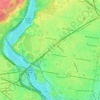
Nombre: Mapa topográfico Strawberry Mansion, altitud, relieve.
Altitud media: 31 m
Altitud mínima: 1 m
Altitud máxima: 74 m
Haz una donación
Otros mapas topográficos
Haga clic en un mapa para ver su topografía, su altitud y su relieve.
Roxborough
United States > Pennsylvania > Philadelphia County > Philadelphia
Since the 1950s, most of Philadelphia's major television and FM radio stations have located their transmission towers in Roxborough because of its hilly terrain and high elevation. The tallest of these towers, the American Tower, stands approximately 1,250 feet (381m) tall. Public television station "MiND",…
Altitud media: 63 m
East Falls
United States > Pennsylvania > Philadelphia County > Philadelphia
East Falls takes its name from its location on the east side of the Schuylkill Falls along the Schuylkill River at the original line of waterfalls known as the 'Falls of the Schuylkill' where the river descends from the elevation of the Pennsylvania piedmont to the coastal plain occupied by the main part of…
Altitud media: 54 m
East Passyunk Community Recreation Center
United States > Pennsylvania > Philadelphia County > Philadelphia
Altitud media: 9 m
Haz una donación
Wissahickon Valley Park
United States > Pennsylvania > Philadelphia County > Philadelphia
Altitud media: 77 m
Chestnut Hill
United States > Pennsylvania > Philadelphia County > Philadelphia
The village of Chestnut Hill was part of the German Township laid out by Francis Daniel Pastorius and came to include the settlements originally known as Sommerhausen and Crefeld, as well as part of Cresheim. It served as a gateway between Philadelphia and the nearby farmlands. During the American…
Altitud media: 97 m
Bartram's Garden
United States > Pennsylvania > Philadelphia County > Philadelphia
Altitud media: 13 m