
Gracias por apoyar a este sitio ❤️
Haz una donación
Haz una donación
Mapa topográfico Skytop
Haga clic en el mapa para ver la altitud.
Gracias por apoyar a este sitio ❤️
Haz una donación
Haz una donación
Skytop
Skytop is an unincorporated community in Barrett Township, Monroe County, Pennsylvania, United States. Located north of Mountainhome, it is accessible by local roads off Route 390. Its elevation is 1,562 feet (476 m), and it is located at 41°13′40″N 75°14′18″W / 41.22778°N 75.23833°W / 41.22778; -75.23833 (41.2278683, -75.2382360). Although Skytop is unincorporated, it has a post office, with the ZIP code of 18357; the ZCTA for ZIP Code 18357 had a population of 87 at the 2000 census.
Gracias por apoyar a este sitio ❤️
Haz una donación
Haz una donación
Acerca de este mapa
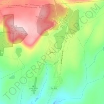
Nombre: Mapa topográfico Skytop, altitud, relieve.
Altitud media: 469 m
Altitud mínima: 346 m
Altitud máxima: 622 m
Gracias por apoyar a este sitio ❤️
Haz una donación
Haz una donación