
Haz una donación
Mapa topográfico Scarborough
Haga clic en el mapa para ver la altitud.
Haz una donación
Scarborough
The climate is temperate with mild summers and cool, windy, winters. The hottest months of the year are July and August, with temperatures reaching an average high of 17 °C and falling to 11 °C at night. The average daytime temperatures in January are 4 °C, falling to 1 °C at night. The station's elevation of 110 m (360 ft) is far above sea level compared to the immediate coastline, where the climate is likely slightly milder year round.
Haz una donación
Acerca de este mapa
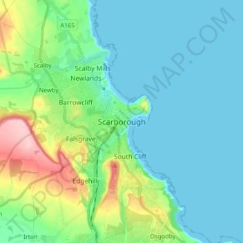
Nombre: Mapa topográfico Scarborough, altitud, relieve.
Altitud media: 39 m
Altitud mínima: -1 m
Altitud máxima: 184 m
Haz una donación
Otros mapas topográficos
Haga clic en un mapa para ver su topografía, su altitud y su relieve.
Scarborough
United Kingdom > England > North Yorkshire > Scarborough
The climate is temperate with mild summers and cool, windy, winters. The hottest months of the year are July and August, with temperatures reaching an average high of 17 °C and falling to 11 °C at night. The average daytime temperatures in January are 4 °C, falling to 1 °C at night. The station's elevation…
Altitud media: 50 m
Craven
United Kingdom > England > North Yorkshire
Vegetation in the Pennines is adapted to subarctic climates, but altitude and acidity are also factors. For example, on Sutton Moor the millstone grit's topsoil below 275 m (902 ft) has a soil ph that is almost neutral, ph 6 to 7, and so grows good grazing. However, above 275 m (902 ft) it is acidic, ph 2 to…
Altitud media: 294 m