
Haz una donación
Mapa topográfico Craven
Haga clic en el mapa para ver la altitud.
Haz una donación
Craven
Vegetation in the Pennines is adapted to subarctic climates, but altitude and acidity are also factors. For example, on Sutton Moor the millstone grit's topsoil below 275 m (902 ft) has a soil ph that is almost neutral, ph 6 to 7, and so grows good grazing. However, above 275 m (902 ft) it is acidic, ph 2 to 4, and so can grow only bracken, heather, sphagnum, and coarse grasses such as cottongrass, purple moor grass and heath rush. However dressing it with lime produces better quality grass for sheep grazing. Such is named marginal upland grazing. This suggests that early pastoral farming on millstone grit soil flourished in areas where lime was most easily available.
Haz una donación
Acerca de este mapa
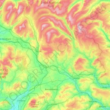
Nombre: Mapa topográfico Craven, altitud, relieve.
Lugar: Craven, North Yorkshire, England, United Kingdom (53.85013 -2.56474 54.25714 -1.81673)
Altitud media: 294 m
Altitud mínima: 38 m
Altitud máxima: 729 m
Haz una donación
Otros mapas topográficos
Haga clic en un mapa para ver su topografía, su altitud y su relieve.
Scarborough
United Kingdom > England > North Yorkshire
The climate is temperate with mild summers and cool, windy, winters. The hottest months of the year are July and August, with temperatures reaching an average high of 17 °C and falling to 11 °C at night. The average daytime temperatures in January are 4 °C, falling to 1 °C at night. The station's elevation…
Altitud media: 39 m