
Mapa topográfico Ocean County
Mapa interactivo
Haga clic en el mapa para ver la altitud.
Acerca de este mapa
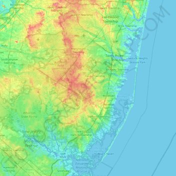
Nombre: Mapa topográfico Ocean County, altitud, relieve.
Lugar: Ocean County, New Jersey, United States of America (39.47520 -74.55311 40.17236 -73.96611)
Altitud media: 15 m
Altitud mínima: -2 m
Altitud máxima: 78 m
Much of the county is flat and coastal, with many beaches. The highest point is one of three unnamed hills (one in Jackson Township, the other two in Plumsted Township) that reach at least 230 feet (70 m) in elevation. The lowest elevation in the county is sea level.
Otros mapas topográficos
Haga clic en un mapa para ver su topografía, su altitud y su relieve.
Mercer County
United States of America > New Jersey
Mercer County, New Jersey, United States of America
Altitud media: 43 m
Ridgewood
United States of America > New Jersey > Ridgewood
Ridgewood, Bergen County, New Jersey, United States of America
Altitud media: 51 m
Ho-Ho-Kus
United States of America > New Jersey > Ho-Ho-Kus
Ho-Ho-Kus, Bergen County, New Jersey, United States of America
Altitud media: 58 m
Passaic County
United States of America > New Jersey
Passaic County, New Jersey, United States of America
Altitud media: 182 m
Trenton
United States of America > New Jersey > Trenton
Trenton, Mercer County, New Jersey, United States of America
Altitud media: 19 m
Hudson County
United States of America > New Jersey
Hudson County, New Jersey, United States of America
Altitud media: 12 m