
Mapa topográfico Hudson County
Mapa interactivo
Haga clic en el mapa para ver la altitud.
Acerca de este mapa
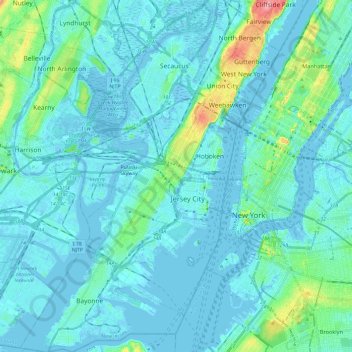
Nombre: Mapa topográfico Hudson County, altitud, relieve.
Lugar: Hudson County, New Jersey, United States of America (40.64215 -74.16609 40.82357 -73.98488)
Altitud media: 12 m
Altitud mínima: -9 m
Altitud máxima: 98 m
The topography is marked by the New Jersey Palisades in the north with cliffs overlooking the Hudson to the east and less severe cuesta, or slope, to the west. They gradually level off to the southern peninsula, which is coastal and flat. The western region, around the Hackensack and Passaic is part of the New Jersey Meadowlands. Much of the land along the county's extensive shoreline and littoral zone was created by land reclamation.
Otros mapas topográficos
Haga clic en un mapa para ver su topografía, su altitud y su relieve.
Mercer County
United States of America > New Jersey
Mercer County, New Jersey, United States of America
Altitud media: 43 m
Ridgewood
United States of America > New Jersey > Ridgewood
Ridgewood, Bergen County, New Jersey, United States of America
Altitud media: 51 m
Ho-Ho-Kus
United States of America > New Jersey > Ho-Ho-Kus
Ho-Ho-Kus, Bergen County, New Jersey, United States of America
Altitud media: 58 m
Ocean County
United States of America > New Jersey
Ocean County, New Jersey, United States of America
Altitud media: 15 m
Passaic County
United States of America > New Jersey
Passaic County, New Jersey, United States of America
Altitud media: 182 m
Trenton
United States of America > New Jersey > Trenton
Trenton, Mercer County, New Jersey, United States of America
Altitud media: 19 m