
Haz una donación
Mapa topográfico Schodack Center
Haga clic en el mapa para ver la altitud.
Haz una donación
Acerca de este mapa
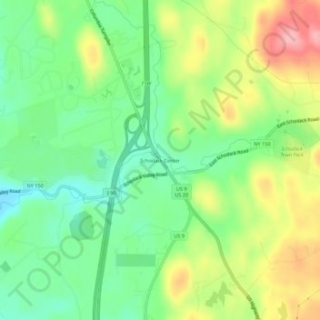
Nombre: Mapa topográfico Schodack Center, altitud, relieve.
Altitud media: 117 m
Altitud mínima: 64 m
Altitud máxima: 194 m
Haz una donación
Otros mapas topográficos
Haga clic en un mapa para ver su topografía, su altitud y su relieve.
East Greenbush CDP
United States > New York > Rensselaer County > Town of East Greenbush
The western section of the town along the Hudson River is marked by bluffs that rise to an elevation of between 100 and 300 feet. The little flat land that exists along the river is on the Papscanee Island. Papscanee Island is actually a peninsula, separated from the rest of the town by the Papscanee Creek.…
Altitud media: 96 m
Town of East Greenbush
United States > New York > Rensselaer County
The western section of the town, along the Hudson River is marked by bluffs that rise to an elevation of between 100 and 300 feet. The little flat land that exists along the river is on the Papscanee Island. Papscanee Island is actually a peninsula, separated from the rest of the town by the Papscanee Creek.…
Altitud media: 89 m
Haz una donación
Walloomsac Dam
United States > New York > Rensselaer County > Town of Hoosick > Walloomsac
Altitud media: 191 m
Haz una donación
Haz una donación