
Haz una donación
Mapa topográfico West Sand Lake
Haga clic en el mapa para ver la altitud.
Haz una donación
Acerca de este mapa
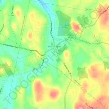
Nombre: Mapa topográfico West Sand Lake, altitud, relieve.
Altitud media: 181 m
Altitud mínima: 136 m
Altitud máxima: 234 m
Haz una donación
Otros mapas topográficos
Haga clic en un mapa para ver su topografía, su altitud y su relieve.
Troy
United States > New York > Rensselaer County
The western edge of the city is flat along the river, and then steeply slopes to higher terrain to the east. The average elevation is 50 feet, with the highest elevation being 500 feet in the eastern part of the city. The city is longer than it is wide, with the southern part wider than the northern section of…
Altitud media: 137 m
Haz una donación
Walloomsac Dam
United States > New York > Rensselaer County > Town of Hoosick > Walloomsac
Altitud media: 191 m
Haz una donación
Stephentown Center
United States > New York > Rensselaer County > Town of Stephentown
Altitud media: 387 m
Haz una donación
West Stephentown
United States > New York > Rensselaer County > Town of Stephentown
Altitud media: 398 m
Haz una donación
Haz una donación