
Haz una donación
Mapa topográfico Cape Coral
Haga clic en el mapa para ver la altitud.
Haz una donación
Acerca de este mapa
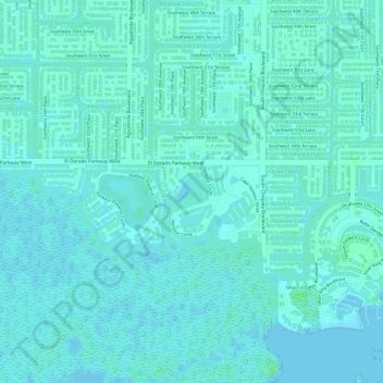
Nombre: Mapa topográfico Cape Coral, altitud, relieve.
Altitud media: 3 m
Altitud mínima: 0 m
Altitud máxima: 7 m
Haz una donación
Otros mapas topográficos
Haga clic en un mapa para ver su topografía, su altitud y su relieve.
Saint James Mobile Home Park
United States > Florida > Lee County > Saint James City
Altitud media: 1 m
Haz una donación
Caloosahatchee River
United States > Florida > Lee County
Until late in the 19th century, the Caloosahatchee River was fed by a series of lakes starting from Lake Hicpochee, and including Lettuce Lake, Bonnet Lake and Flirt Lake. A waterfall and set of rapids at the lower end of Flirt Lake marked the beginning of the river. The rapids were close to 1 mile (1.6 km)…
Altitud media: 8 m
Riverbend Golf and River Club
United States > Florida > Lee County > North Fort Myers
Altitud media: 3 m
Haz una donación
Haz una donación
Bonita National Golf & Country Club
United States > Florida > Lee County > Bonita Springs
Altitud media: 5 m
Haz una donación
Haz una donación
Spring Creek Village
United States > Florida > Lee County > Bonita Springs > Pelican Landing
Altitud media: 4 m
Haz una donación
Haz una donación
Herons Glen Golf and Country Club
United States > Florida > Lee County > Herons Glen Golf and Country Club
Altitud media: 8 m
Haz una donación
Haz una donación
Haz una donación
Haz una donación
Haz una donación
Highland Woods Golf & Country Club
United States > Florida > Lee County > Bonita Springs
Altitud media: 5 m
Haz una donación
Haz una donación
Haz una donación
Swan Lake Travel Trailer Park
United States > Florida > Lee County > North Fort Myers
Altitud media: 6 m
Haz una donación
Haz una donación
Pioneer Village RV Resort & Resort Community
United States > Florida > Lee County > North Fort Myers
Altitud media: 4 m
Haz una donación
Haz una donación
Six Lakes Country Club
United States > Florida > Lee County > North Fort Myers > Six Lakes Country Club
Altitud media: 5 m
Haz una donación
Rapallo at Coconut Point
United States > Florida > Lee County > Shadow Wood > Rapallo at Coconut Point
Altitud media: 6 m
Haz una donación
Haz una donación
Estero Bay Preserve State Park
United States > Florida > Lee County > Fort Myers Beach
Altitud media: 2 m
Haz una donación
Caloosa Mobile Home Village
United States > Florida > Lee County > North Fort Myers
Altitud media: 2 m
Calusa Land Trust and Nature Preserve of Pine Island
United States > Florida > Lee County > Cape Coral
Altitud media: 1 m