
Haz una donación
Mapa topográfico Pine Island
Haga clic en el mapa para ver la altitud.
Haz una donación
Acerca de este mapa
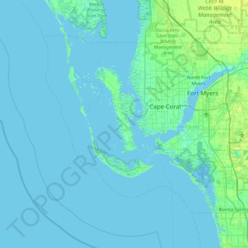
Nombre: Mapa topográfico Pine Island, altitud, relieve.
Lugar: Pine Island, Lee County, Florida, 33956, United States (26.23924 -82.41981 26.87924 -81.77981)
Altitud media: 2 m
Altitud mínima: -1 m
Altitud máxima: 24 m
Haz una donación
Otros mapas topográficos
Haga clic en un mapa para ver su topografía, su altitud y su relieve.
Caloosahatchee River
United States > Florida > Lee County
Until late in the 19th century, the Caloosahatchee River was fed by a series of lakes starting from Lake Hicpochee, and including Lettuce Lake, Bonnet Lake and Flirt Lake. A waterfall and set of rapids at the lower end of Flirt Lake marked the beginning of the river. The rapids were close to 1 mile (1.6 km)…
Altitud media: 8 m
North Shore Park
United States > Florida > Lee County > North Fort Myers > Sunset North Condominiums
Altitud media: 1 m
Haz una donación
Haz una donación
Haz una donación
Haz una donación
Haz una donación
Haz una donación
Estero Bay Preserve State Park
United States > Florida > Lee County > Fort Myers Beach
Altitud media: 2 m
Calusa Land Trust and Nature Preserve of Pine Island
United States > Florida > Lee County > Cape Coral
Altitud media: 1 m