
Haz una donación
Mapa topográfico Matupi Township
Haga clic en el mapa para ver la altitud.
Haz una donación
Matupi Township
Agriculture is the most essential and profitable industry in the Matupi Township, employing more than 90% of the population. Common crops include rice, wheat, corn, millet, pulses, oilseeds, coffee, oranges, damson, potatoes, and natural fibres. However, Matupi still depends on the import of rice supplies from the lowlands. Although the primary occupation is agriculture, the industry is not well developed due to the scarcity of large valleys and plains. Shifting cultivation is still prevalent. Terraced cultivation is slowly being introduced along the hillsides. Due to difficult terrain, human labor is the main driving force of the work done. Teak and other hardwoods are found at elevation below 900 metres (3,000 ft). Oaks and pines grow at altitudes above 900 metres (3,000 ft). Teak, pines, canes, resin and turpentine are important forest products. Since electricity is not available in most villages, people depend on firewood for cooking. Forestry is also a main source of income.
Haz una donación
Acerca de este mapa
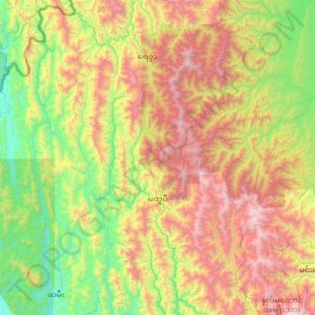
Nombre: Mapa topográfico Matupi Township, altitud, relieve.
Lugar: Matupi Township, Mindat District, Chin, Myanmar (21.23314 93.01471 22.23019 94.01750)
Altitud media: 940 m
Altitud mínima: 4 m
Altitud máxima: 2 772 m
Haz una donación
Otros mapas topográficos
Haga clic en un mapa para ver su topografía, su altitud y su relieve.