
Gracias por apoyar a este sitio ❤️
Haz una donación
Haz una donación
Mapa topográfico Kace
Haga clic en el mapa para ver la altitud.
Gracias por apoyar a este sitio ❤️
Haz una donación
Haz una donación
Acerca de este mapa
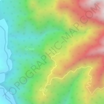
Nombre: Mapa topográfico Kace, altitud, relieve.
Lugar: Kace, Matupi Township, Mindat District, Chin, Myanmar (21.70781 93.36002 21.74781 93.40002)
Altitud media: 958 m
Altitud mínima: 458 m
Altitud máxima: 1 703 m
Gracias por apoyar a este sitio ❤️
Haz una donación
Haz una donación
Otros mapas topográficos
Haga clic en un mapa para ver su topografía, su altitud y su relieve.
Matupi Township
Myanmar > Chin > Mindat District
Agriculture is the most essential and profitable industry in the Matupi Township, employing more than 90% of the population. Common crops include rice, wheat, corn, millet, pulses, oilseeds, coffee, oranges, damson, potatoes, and natural fibres. However, Matupi still depends on the import of rice supplies from…
Altitud media: 940 m