
Mapa topográfico Mount Aspiring National Park
Mapa interactivo
Haga clic en el mapa para ver la altitud.
Acerca de este mapa
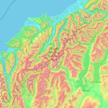
Nombre: Mapa topográfico Mount Aspiring National Park, altitud, relieve.
Lugar: Mount Aspiring National Park, West Coast, New Zealand (-44.77441 168.16919 -43.92539 169.59288)
Altitud media: 770 m
Altitud mínima: -2 m
Altitud máxima: 2 913 m
Otros mapas topográficos
Haga clic en un mapa para ver su topografía, su altitud y su relieve.
Westland District
Westland District, West Coast, New Zealand
Altitud media: 437 m
Mokihinui
New Zealand > West Coast > Buller District
Mokihinui, Buller District, West Coast, New Zealand
Altitud media: 55 m
Charleston
New Zealand > West Coast > Buller District
Charleston, Buller District, West Coast, New Zealand
Altitud media: 24 m
Granity
New Zealand > West Coast > Buller District
Granity, Buller District, West Coast, New Zealand
Altitud media: 150 m
Okuru
New Zealand > West Coast > Westland District
Okuru, Westland District, West Coast, New Zealand
Altitud media: 3 m
Gillespies Beach
New Zealand > West Coast > Westland District
Gillespies Beach, Westland District, West Coast, New Zealand
Altitud media: 14 m
Greymouth
New Zealand > West Coast > Grey District
Greymouth, Grey District, West Coast, 7801, New Zealand
Altitud media: 40 m
Hokitika
New Zealand > West Coast > Westland District
Hokitika, Westland District, West Coast, 7810, New Zealand
Altitud media: 14 m
Atarau
New Zealand > West Coast > Grey District
Atarau, Grey District, West Coast, 7843, New Zealand
Altitud media: 59 m
Lewis Pass
New Zealand > West Coast > Buller District
Lewis Pass, Buller District, West Coast, New Zealand
Altitud media: 1 039 m
Waikowai Stream
New Zealand > West Coast > Westland District
Waikowai Stream, Westland District, West Coast, New Zealand
Altitud media: 13 m
Taylorville
New Zealand > West Coast > Grey District
Taylorville, Grey District, West Coast, New Zealand
Altitud media: 125 m
Cape Foulwind
New Zealand > West Coast > Buller District > Cape Foulwind
Cape Foulwind, Buller District, West Coast, New Zealand
Altitud media: 14 m
Hooker Glacier
New Zealand > West Coast > Westland District
Hooker Glacier, Westland District, West Coast, New Zealand
Altitud media: 1 930 m
Lake Brunner
New Zealand > West Coast > Grey District > Moana
Lake Brunner, Moana, Grey District, West Coast, New Zealand
Altitud media: 168 m
Belmont
New Zealand > West Coast > Westland District
Belmont, Westland District, West Coast, New Zealand
Altitud media: 1 623 m
Hukarere
New Zealand > West Coast > Buller District
Hukarere, Buller District, West Coast, New Zealand
Altitud media: 131 m
Ikamatua
New Zealand > West Coast > Buller District
Ikamatua, Buller District, West Coast, New Zealand
Altitud media: 122 m
Ngahere
New Zealand > West Coast > Grey District > Ngahere
Ngahere, Grey District, West Coast, 7804, New Zealand
Altitud media: 49 m
Westport
New Zealand > West Coast > Buller District
Westport, Buller District, West Coast, 7825, New Zealand
Altitud media: 13 m
Haast
New Zealand > West Coast > Westland District
Haast, Westland District, West Coast, New Zealand
Altitud media: 15 m
Fox Glacier
New Zealand > West Coast > Westland District
Fox Glacier, Westland District, West Coast, New Zealand
Altitud media: 1 848 m
Franz Josef
New Zealand > West Coast > Westland District
Franz Josef, Westland District, West Coast, 7856, New Zealand
Altitud media: 277 m
Reefton
New Zealand > West Coast > Buller District
Reefton, Buller District, West Coast, 7830, New Zealand
Altitud media: 310 m
Ahaura River
New Zealand > West Coast > Grey District
Ahaura River, Grey District, West Coast, 7843, New Zealand
Altitud media: 386 m
Mount Tasman
New Zealand > West Coast > Westland District
Mount Tasman, Westland District, West Coast, New Zealand
Altitud media: 2 798 m