
Mapa topográfico Haast
Mapa interactivo
Haga clic en el mapa para ver la altitud.
Acerca de este mapa
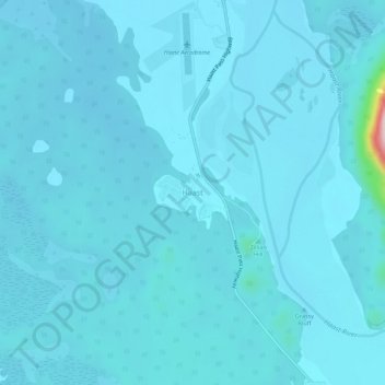
Nombre: Mapa topográfico Haast, altitud, relieve.
Lugar: Haast, Westland District, West Coast, New Zealand (-43.90066 169.02203 -43.86066 169.06203)
Altitud media: 15 m
Altitud mínima: 2 m
Altitud máxima: 271 m
Otros mapas topográficos
Haga clic en un mapa para ver su topografía, su altitud y su relieve.
Okuru
New Zealand > West Coast > Westland District
Okuru, Westland District, West Coast, New Zealand
Altitud media: 3 m
Gillespies Beach
New Zealand > West Coast > Westland District
Gillespies Beach, Westland District, West Coast, New Zealand
Altitud media: 14 m
Hokitika
New Zealand > West Coast > Westland District
Hokitika, Westland District, West Coast, 7810, New Zealand
Altitud media: 14 m
Waikowai Stream
New Zealand > West Coast > Westland District
Waikowai Stream, Westland District, West Coast, New Zealand
Altitud media: 13 m
Hooker Glacier
New Zealand > West Coast > Westland District
Hooker Glacier, Westland District, West Coast, New Zealand
Altitud media: 1 930 m
Belmont
New Zealand > West Coast > Westland District
Belmont, Westland District, West Coast, New Zealand
Altitud media: 1 623 m
Fox Glacier
New Zealand > West Coast > Westland District
Fox Glacier, Westland District, West Coast, New Zealand
Altitud media: 1 848 m
Franz Josef
New Zealand > West Coast > Westland District
Franz Josef, Westland District, West Coast, 7856, New Zealand
Altitud media: 277 m
Mount Tasman
New Zealand > West Coast > Westland District
Mount Tasman, Westland District, West Coast, New Zealand
Altitud media: 2 798 m