
Haz una donación
Mapa topográfico White Haven
Haga clic en el mapa para ver la altitud.
Haz una donación
White Haven
White Haven is located at 41°3′34″N 75°46′34″W / 41.05944°N 75.77611°W / 41.05944; -75.77611 (41.059532, -75.776123). The borough is 17 miles (27 km) south of Wilkes-Barre, and 4 miles (6 km) west of the I-476 and I-80 interchange. According to the U.S. Census Bureau, the borough has a total area of 1.2 square miles (3.2 km2), of which 1.2 square miles (3.2 km2) is land and 0.04 square miles (0.1 km2), or 2.12%, is water. White Haven's elevation is 1,221 feet (372 m) above sea level.
Haz una donación
Acerca de este mapa
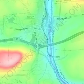
Nombre: Mapa topográfico White Haven, altitud, relieve.
Lugar: White Haven, Luzerne County, Pennsylvania, United States (41.04716 -75.79072 41.06562 -75.76989)
Altitud media: 391 m
Altitud mínima: 324 m
Altitud máxima: 519 m
Haz una donación
Otros mapas topográficos
Haga clic en un mapa para ver su topografía, su altitud y su relieve.
Ricketts Glen State Park
United States > Pennsylvania > Luzerne County > Fairmount Township
The state's original plans for the new park included building an inn, an 18-hole golf course and country club, and a winter sports complex for skiing, ice boating, and tobogganing, as well as a beach with bathing facilities, cabins, and a tent camping area. Only the last three were actually built, all south of…
Altitud media: 588 m
Haz una donación
Haz una donación
Haz una donación
Haz una donación
Liewellyn Corners
United States > Pennsylvania > Luzerne County > Bear Creek Township
Altitud media: 449 m
Haz una donación
Haz una donación
Haz una donación
Hunlock Creek
United States > Pennsylvania > Luzerne County > Hunlock Township > Hunlock
Altitud media: 276 m
Huntington Mills
United States > Pennsylvania > Luzerne County > Huntington Township
Altitud media: 289 m
Haz una donación
Haz una donación
Haz una donación