
Haz una donación
Mapa topográfico Lindbergh
Haga clic en el mapa para ver la altitud.
Haz una donación
Acerca de este mapa
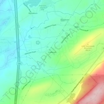
Nombre: Mapa topográfico Lindbergh, altitud, relieve.
Altitud media: 386 m
Altitud mínima: 312 m
Altitud máxima: 566 m
Haz una donación
Otros mapas topográficos
Haga clic en un mapa para ver su topografía, su altitud y su relieve.
Mountain Top
United States > Pennsylvania > Luzerne County > Wright Township
The elevation within the Mountain Top CDP ranges from 1,070 feet (330 m) above sea level along Big Wapwallopen Creek in the southwest, to 1,860 feet (570 m) atop Nescopeck Mountain southwest of Rita, to 1,871 feet (570 m) at the east end of Penobscot Mountain in the north of the CDP. The central village of…
Altitud media: 463 m
Mountain Top
United States > Pennsylvania > Luzerne County > Wright Township
The elevation in Mountain Top ranges from 1,070 feet (330 m) above sea level along Big Wapwallopen Creek in the southwest, to 1,860 feet (570 m) atop Nescopeck Mountain southwest of Rita, to 1,871 feet (570 m) at the east end of Penobscot Mountain in north Mountain Top. The central village of Mountain Top sits…
Altitud media: 463 m
Mountain Top
United States > Pennsylvania > Luzerne County > Wright Township
The elevation within the Mountain Top CDP ranges from 1,070 feet (330 m) above sea level along Big Wapwallopen Creek in the southwest, to 1,860 feet (570 m) atop Nescopeck Mountain southwest of Rita, to 1,871 feet (570 m) at the east end of Penobscot Mountain in the north of the CDP. The central village of…
Altitud media: 463 m