
Gracias por apoyar a este sitio ❤️
Haz una donación
Haz una donación
Mapa topográfico Astoria
Haga clic en el mapa para ver la altitud.
Gracias por apoyar a este sitio ❤️
Haz una donación
Haz una donación
Acerca de este mapa
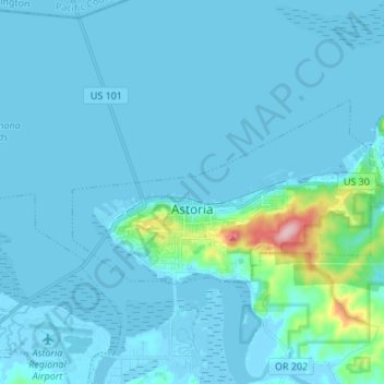
Nombre: Mapa topográfico Astoria, altitud, relieve.
Lugar: Astoria, Clatsop County, Oregon, 97103, United States (46.16995 -123.87418 46.21494 -123.73924)
Altitud media: 15 m
Altitud mínima: -4 m
Altitud máxima: 204 m
Gracias por apoyar a este sitio ❤️
Haz una donación
Haz una donación
Otros mapas topográficos
Haga clic en un mapa para ver su topografía, su altitud y su relieve.
Gracias por apoyar a este sitio ❤️
Haz una donación
Haz una donación
Saddle Mountain
United States > Oregon > Clatsop County
The hike to the taller of the two peaks is a 6-mile (9.7 km) round trip consisting of challenging terrain. Elevation gain is 1,603 feet (489 m) and leads to a 360-degree view to the Pacific Ocean, Cascade Mountain peaks such as Mount Hood, Mount St. Helens, Mount Rainier, Mount Adams, and other peaks in the…
Altitud media: 527 m
Gracias por apoyar a este sitio ❤️
Haz una donación
Haz una donación