
Haz una donación
Mapa topográfico Tillamook Head
Haga clic en el mapa para ver la altitud.
Haz una donación
Acerca de este mapa
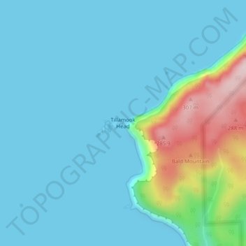
Nombre: Mapa topográfico Tillamook Head, altitud, relieve.
Lugar: Tillamook Head, Clatsop County, Oregon, United States (45.94648 -123.99344 45.94658 -123.99334)
Altitud media: 54 m
Altitud mínima: 0 m
Altitud máxima: 322 m
Haz una donación
Otros mapas topográficos
Haga clic en un mapa para ver su topografía, su altitud y su relieve.
Cannon Beach
United States > Oregon > Clatsop County
Cannon Beach is recognized by the well-known landmark Haystack Rock, located southwest of downtown Cannon Beach. This sea stack has an elevation of 235 feet (72 m) and is often accessible at low tide, especially in the summertime. There is a small cave system that penetrates its igneous rock that can be seen…
Altitud media: 42 m
Haz una donación
Cannon Beach
United States > Oregon > Clatsop County
Cannon Beach is recognized by the well-known landmark Haystack Rock, located southwest of downtown Cannon Beach. This sea stack has an elevation of 235 feet (72 m) and is often accessible at low tide, especially in the summertime. There is a small cave system that penetrates its igneous rock that can be seen…
Altitud media: 42 m
Haz una donación