
Haz una donación
Mapa topográfico Plymouth
Haga clic en el mapa para ver la altitud.
Haz una donación
Acerca de este mapa
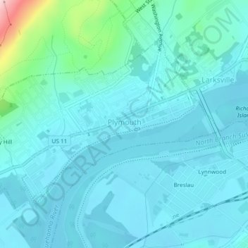
Nombre: Mapa topográfico Plymouth, altitud, relieve.
Lugar: Plymouth, Luzerne County, Pennsylvania, 18651, United States (41.23037 -75.96732 41.24990 -75.93044)
Altitud media: 185 m
Altitud mínima: 152 m
Altitud máxima: 398 m
Haz una donación
Otros mapas topográficos
Haga clic en un mapa para ver su topografía, su altitud y su relieve.
Ricketts Glen State Park
United States > Pennsylvania > Luzerne County > Fairmount Township
The state's original plans for the new park included building an inn, an 18-hole golf course and country club, and a winter sports complex for skiing, ice boating, and tobogganing, as well as a beach with bathing facilities, cabins, and a tent camping area. Only the last three were actually built, all south of…
Altitud media: 588 m
Haz una donación
Haz una donación
Haz una donación
Haz una donación
Haz una donación
Liewellyn Corners
United States > Pennsylvania > Luzerne County > Bear Creek Township
Altitud media: 449 m
Haz una donación
Haz una donación
Hunlock Creek
United States > Pennsylvania > Luzerne County > Hunlock Township > Hunlock
Altitud media: 276 m
Huntington Mills
United States > Pennsylvania > Luzerne County > Huntington Township
Altitud media: 289 m
Haz una donación
Haz una donación
Haz una donación