
Haz una donación
Mapa topográfico Corbett
Haga clic en el mapa para ver la altitud.
Haz una donación
Acerca de este mapa
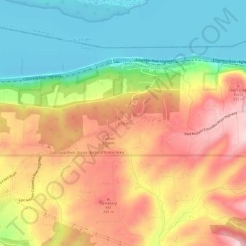
Nombre: Mapa topográfico Corbett, altitud, relieve.
Lugar: Corbett, Multnomah County, Oregon, 97019, United States (45.51145 -122.31226 45.55145 -122.27226)
Altitud media: 127 m
Altitud mínima: -1 m
Altitud máxima: 264 m
Haz una donación
Otros mapas topográficos
Haga clic en un mapa para ver su topografía, su altitud y su relieve.
Portland
United States > Oregon > Multnomah County
Portland features a striking and varied topography characterized by its location at the confluence of the Willamette and Columbia Rivers. The city lies within the fertile Willamette Valley, flanked by the snow-capped Cascade Mountains to the east, including the prominent Mount Hood, and the less elevated…
Altitud media: 77 m
Portland
United States > Oregon > Multnomah County
Annual snowfall in Portland is 4.3 inches (10.9 cm), which usually falls between December and March. The city of Portland avoids snow more frequently than its suburbs, due in part to its low elevation and the urban heat island effect. Neighborhoods outside of the downtown core, especially in slightly higher…
Altitud media: 77 m
Gresham
United States > Oregon > Multnomah County
Though much of Gresham is relatively flat, it is characterized by a hill on its eastern border. Northeast Gresham is also hilly, particularly where the city meets Troutdale toward the Columbia River. Its elevation is 325 feet (99 m). Johnson Creek, which begins at the foothills of the Cascade Mountains, runs…
Altitud media: 90 m
Haz una donación
Hoyt Arboretum
United States > Oregon > Multnomah County > Portland
Hoyt Arboretum is sited on steep slopes, straddling the SW Fairview Boulevard ridge above the Oregon Zoo and the Portland Japanese Garden. The elevation of the arboretum ranges from 650 feet to 900 feet, and there are several ravines within the arboretum. The hilly terrain of the arboretum was once in private…
Altitud media: 209 m
Haz una donación
Haz una donación
Governor Tom McCall Waterfront Park
United States > Oregon > Multnomah County > Portland
Altitud media: 26 m
Portland
United States > Oregon > Multnomah County
Annual snowfall in Portland is 4.3 inches (10.9 cm), which usually falls during the December-to-March time frame. The city of Portland avoids snow more frequently than its suburbs, due in part to its low elevation and urban heat island effect. Neighborhoods outside of the downtown core, especially in slightly…
Altitud media: 77 m
Haz una donación
Portland
United States > Oregon > Multnomah County
Annual snowfall in Portland is 4.3 inches (10.9 cm), which usually falls between December and March. The city of Portland avoids snow more frequently than its suburbs, due in part to its low elevation and the urban heat island effect. Neighborhoods outside of the downtown core, especially in slightly higher…
Altitud media: 77 m
Haz una donación
Gresham
United States > Oregon > Multnomah County
Gresham is characterized by hills on its eastern border. Northeast Gresham is also hilly, especially where the city meets Troutdale toward the Columbia River. Its elevation is 325 feet (99 m). Johnson Creek, which begins at the foothills of the Cascade Mountains, runs westward through Gresham, with 23 percent…
Altitud media: 89 m
Portland
United States > Oregon > Multnomah County
Annual snowfall in Portland is 4.3 inches (10.9 cm), which usually falls between December and March. The city of Portland avoids snow more frequently than its suburbs, due in part to its low elevation and the urban heat island effect. Neighborhoods outside of the downtown core, especially in slightly higher…
Altitud media: 77 m
Haz una donación
Haz una donación
Portland
United States > Oregon > Multnomah County
Annual snowfall in Portland is 4.3 inches (10.9 cm), which usually falls between December and March. The city of Portland avoids snow more frequently than its suburbs, due in part to its low elevation and the urban heat island effect. Neighborhoods outside of the downtown core, especially in slightly higher…
Altitud media: 77 m
Gresham
United States > Oregon > Multnomah County
Though much of Gresham is relatively flat, it is characterized by a hill on its eastern border. Northeast Gresham is also hilly, particularly where the city meets Troutdale toward the Columbia River. Its elevation is 325 feet (99 m). Johnson Creek, which begins at the foothills of the Cascade Mountains, runs…
Altitud media: 90 m
Portland
United States > Oregon > Multnomah County
Annual snowfall in Portland is 4.3 inches (10.9 cm), which usually falls between December and March. The city of Portland avoids snow more frequently than its suburbs, due in part to its low elevation and the urban heat island effect. Neighborhoods outside of the downtown core, especially in slightly higher…
Altitud media: 77 m
Haz una donación