
Haz una donación
Mapa topográfico Troutdale
Haga clic en el mapa para ver la altitud.
Haz una donación
Acerca de este mapa
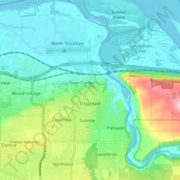
Nombre: Mapa topográfico Troutdale, altitud, relieve.
Lugar: Troutdale, Multnomah County, Oregon, 97060, United States (45.50648 -122.43033 45.56576 -122.36749)
Altitud media: 54 m
Altitud mínima: -1 m
Altitud máxima: 221 m
Haz una donación
Otros mapas topográficos
Haga clic en un mapa para ver su topografía, su altitud y su relieve.
Rocky Butte
United States > Oregon > Multnomah County > Portland
Rocky Butte lies in the northeast part of Portland within the city limits, in Multnomah County, part of the U. S. state of Oregon. It is one of the few smaller volcanic cones within or near Portland, along with Mount Tabor, Kelly Butte, and Powell Butte. According to the U.S. National Geodetic Survey, Rocky…
Altitud media: 67 m
Haz una donación
Haz una donación
Governor Tom McCall Waterfront Park
United States > Oregon > Multnomah County > Portland
Altitud media: 26 m
Haz una donación
Haz una donación