
Haz una donación
Mapa topográfico Wilkes-Barre
Haga clic en el mapa para ver la altitud.
Haz una donación
Wilkes-Barre
According to the U.S. Census Bureau, the city has a total area of 7.2 square miles (19 km2), of which 6.8 square miles (18 km2) is land and 0.3 square miles (0.78 km2), or 4.60%, is water. The city is bordered by the Susquehanna River to the west. Most of Downtown is located on a wide floodplain. Floodwalls were constructed to protect a large percentage of the city. The elevation of the downtown area is about 550 feet (170 m) above sea level. As you travel inland, away from the river, the elevation rises. Wilkes-Barre Mountain is a physical barrier southeast of the city.
Haz una donación
Acerca de este mapa
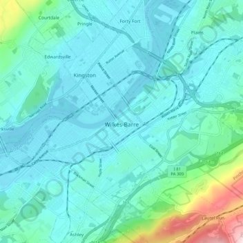
Nombre: Mapa topográfico Wilkes-Barre, altitud, relieve.
Lugar: Wilkes-Barre, Luzerne County, Pennsylvania, United States (41.22193 -75.92814 41.27292 -75.82685)
Altitud media: 218 m
Altitud mínima: 154 m
Altitud máxima: 574 m
Haz una donación
Otros mapas topográficos
Haga clic en un mapa para ver su topografía, su altitud y su relieve.
Ricketts Glen State Park
United States > Pennsylvania > Luzerne County > Fairmount Township
The state's original plans for the new park included building an inn, an 18-hole golf course and country club, and a winter sports complex for skiing, ice boating, and tobogganing, as well as a beach with bathing facilities, cabins, and a tent camping area. Only the last three were actually built, all south of…
Altitud media: 588 m
Haz una donación
Haz una donación
Haz una donación
Haz una donación
Haz una donación
Liewellyn Corners
United States > Pennsylvania > Luzerne County > Bear Creek Township
Altitud media: 449 m
Haz una donación
Haz una donación
Hunlock Creek
United States > Pennsylvania > Luzerne County > Hunlock Township > Hunlock
Altitud media: 276 m
Huntington Mills
United States > Pennsylvania > Luzerne County > Huntington Township
Altitud media: 289 m
Haz una donación
Haz una donación
Haz una donación