
Haz una donación
Mapa topográfico Shickshinny
Haga clic en el mapa para ver la altitud.
Haz una donación
Shickshinny
According to the United States Census Bureau, the borough has a total area of 0.50 square miles (1.3 km2), of which 0.46 square miles (1.2 km2) is land and 0.04 square miles (0.1 km2), or 9.34%, is water. Shickshinny's terrain is flat in the east; the elevation increases as you move westward. Shickshinny is made up of homes and businesses; the borough is surrounded by thick forests. The Susquehanna Warrior Trail passes through Shickshinny.
Haz una donación
Acerca de este mapa
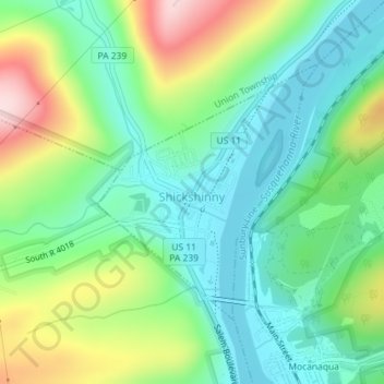
Nombre: Mapa topográfico Shickshinny, altitud, relieve.
Lugar: Shickshinny, Luzerne County, Pennsylvania, United States (41.14440 -76.15903 41.16252 -76.13832)
Altitud media: 246 m
Altitud mínima: 144 m
Altitud máxima: 462 m
Haz una donación
Otros mapas topográficos
Haga clic en un mapa para ver su topografía, su altitud y su relieve.
Ricketts Glen State Park
United States > Pennsylvania > Luzerne County > Fairmount Township
The state's original plans for the new park included building an inn, an 18-hole golf course and country club, and a winter sports complex for skiing, ice boating, and tobogganing, as well as a beach with bathing facilities, cabins, and a tent camping area. Only the last three were actually built, all south of…
Altitud media: 588 m
Haz una donación
Haz una donación
Haz una donación
Haz una donación
Liewellyn Corners
United States > Pennsylvania > Luzerne County > Bear Creek Township
Altitud media: 449 m
Haz una donación
Haz una donación
Haz una donación
Hunlock Creek
United States > Pennsylvania > Luzerne County > Hunlock Township > Hunlock
Altitud media: 276 m
Huntington Mills
United States > Pennsylvania > Luzerne County > Huntington Township
Altitud media: 289 m
Haz una donación
Haz una donación
Haz una donación