
Mapa topográfico Baralacha Pass
Mapa interactivo
Haga clic en el mapa para ver la altitud.
Acerca de este mapa
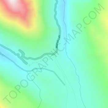
Nombre: Mapa topográfico Baralacha Pass, altitud, relieve.
Altitud media: 4 983 m
Altitud mínima: 4 770 m
Altitud máxima: 5 595 m
"The Bara Lacha is the boundary between two separate regions distinguished by their physical characteristics. That which we have already passed through may be called the true Himalayan region. Here the gigantic ranges are covered with perpetual snow, furrowed by glaciers, and they arise from amid dense forests which clothe their flanks up to a certain elevation. They are separated by deep gorges, whose sides are precipices, and though which large rivers flow. In fact the scenery is Alpine.
Otros mapas topográficos
Haga clic en un mapa para ver su topografía, su altitud y su relieve.
Yamling
India > Himachal Pradesh > Lahul
Yamling, Lahul, Lahaul and Spiti District, Himachal Pradesh, India
Altitud media: 3 420 m
Rohtang Pass
India > Himachal Pradesh > Lahul
Rohtang Pass, Lahul, Lahul and Spiti, Himachal Pradesh, India
Altitud media: 4 042 m
Bara Shigri Glacier
India > Himachal Pradesh > Lahul
Bara Shigri Glacier, Lahul, Lahul and Spiti, Himachal Pradesh, India
Altitud media: 5 369 m
Sarchu
India > Himachal Pradesh > Lahul
Sarchu, Lahul, Lahul and Spiti, Himachal Pradesh, India
Altitud media: 5 408 m
Keylang
India > Himachal Pradesh > Lahul > Keylang
Keylang, Lahul, Lahul and Spiti, Himachal Pradesh, 175132, India
Altitud media: 3 827 m
Lahul
India > Himachal Pradesh > Lahul
Lahul, Lahul and Spiti, Himachal Pradesh, India
Altitud media: 4 551 m