
Mapa topográfico Geneva
Mapa interactivo
Haga clic en el mapa para ver la altitud.
Acerca de este mapa
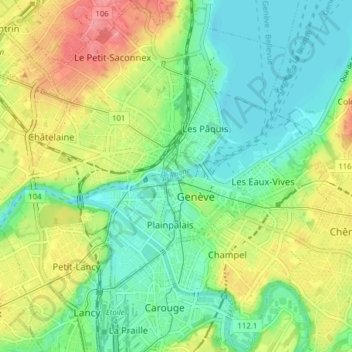
Nombre: Mapa topográfico Geneva, altitud, relieve.
Lugar: Geneva, Switzerland (46.17777 6.11024 46.23189 6.17585)
Altitud media: 404 m
Altitud mínima: 367 m
Altitud máxima: 474 m
The altitude of Geneva is 373.6 m (1,225.7 ft) and corresponds to the altitude of the largest of the Pierres du Niton, two large rocks emerging from the lake which date from the last ice age. This rock was chosen by General Guillaume Henri Dufour as the reference point for surveying in Switzerland. The second main river of Geneva is the Arve, which flows into the Rhône just west of the city centre. Mont Blanc can be seen from Geneva and is an hour's drive from the city.
Otros mapas topográficos
Haga clic en un mapa para ver su topografía, su altitud y su relieve.
Dardagny Castle
Switzerland > Geneva > Dardagny
Dardagny Castle, 520, Route du Mandement, Dardagny, Geneva, 1283, Switzerland
Altitud media: 431 m
Le Grand-Saconnex
Switzerland > Geneva > Le Grand-Saconnex > Le Grand-Saconnex
Le Grand-Saconnex, Grand Genève, Geneva, 1218, Switzerland
Altitud media: 414 m