
Haz una donación
Mapa topográfico Smith Corners
Haga clic en el mapa para ver la altitud.
Haz una donación
Acerca de este mapa
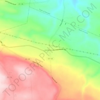
Nombre: Mapa topográfico Smith Corners, altitud, relieve.
Altitud media: 352 m
Altitud mínima: 192 m
Altitud máxima: 522 m
Haz una donación
Otros mapas topográficos
Haga clic en un mapa para ver su topografía, su altitud y su relieve.
Dolgeville Dam
United States > New York > Herkimer County > Village of Dolgeville
Altitud media: 256 m
Haz una donación
Trenton Falls - Main Dam
United States > New York > Herkimer County > Town of Russia
Altitud media: 321 m
Haz una donación
Haz una donación
Haz una donación
Herkimer
United States > New York > Herkimer County > Herkimer
In 1722, in response to a request by the German Palatine leaders Joseph Petrie and Conrad Rickert, Governor William Burnet granted the Palatines a lease to purchase land from the Mohawk Nation in the vicinity of the confluence of West Canada Creek and the Mohawk River. After a survey of the land was completed…
Altitud media: 154 m
Haz una donación
Village of Ilion
United States > New York > Herkimer County > Town of German Flatts
Altitud media: 151 m
Haz una donación
Haz una donación