
Haz una donación
Mapa topográfico Asperg
Haga clic en el mapa para ver la altitud.
Haz una donación
Asperg
The city (Stadt) of Asperg covers 5.38 square kilometers (2.08 sq mi) of the district of Ludwigsburg, in Baden-Württemberg, one of the 16 States of the Federal Republic of Germany. Asperg is physically located in the basin [de] of the Neckar river. Elevation above sea level in the municipal area ranges from a low of 241 meters (791 ft) Normalnull (NN) to a high of 352 meters (1,155 ft) NN.
Haz una donación
Acerca de este mapa
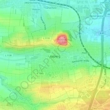
Nombre: Mapa topográfico Asperg, altitud, relieve.
Lugar: Asperg, Landkreis Ludwigsburg, Baden-Württemberg, 71679, Germany (48.89139 9.12281 48.92101 9.16301)
Altitud media: 280 m
Altitud mínima: 242 m
Altitud máxima: 348 m
Haz una donación
Otros mapas topográficos
Haga clic en un mapa para ver su topografía, su altitud y su relieve.
Rielingshausen
Germany > Baden-Württemberg > Landkreis Ludwigsburg > Marbach am Neckar
Altitud media: 291 m
Nussdorf
Germany > Baden-Württemberg > Landkreis Ludwigsburg
The municipality (Gemeinde) of Eberdingen is located at the western extremity of the district of Ludwigsburg, in the German state of Baden-Württemberg, along its border with the districts of Böblingen and the Enz. Eberdingen is physically located in the basin of [de] the Neckar. Elevation above sea level in…
Altitud media: 321 m
Haz una donación