
Mapa topográfico Seia
Mapa interactivo
Haga clic en el mapa para ver la altitud.
Acerca de este mapa
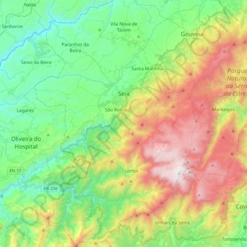
Nombre: Mapa topográfico Seia, altitud, relieve.
Lugar: Seia, Guarda, Portugal (40.22992 -7.84923 40.53552 -7.58343)
Altitud media: 754 m
Altitud mínima: 150 m
Altitud máxima: 1 989 m
The municipality is limited to the north by the municipalities of Nelas and Mangualde, to the northeast by Gouveia, to the east by Manteigas, to the southeast by Covilhã, to the southwest by Arganil and to the west by Oliveira do Hospital. In this municipality is located the highest point in mainland Portugal, Torre, in Serra da Estrela, with 1,993 meters of altitude. The municipality of Seia covers a large part of Serra da Estrela and is also the only one in Portugal where there is a natural ski resort, Vodafone Ski Resort, located within the limits of the parish of Loriga.
Otros mapas topográficos
Haga clic en un mapa para ver su topografía, su altitud y su relieve.