
Mapa topográfico Cornan West
Mapa interactivo
Haga clic en el mapa para ver la altitud.
Acerca de este mapa
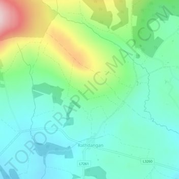
Nombre: Mapa topográfico Cornan West, altitud, relieve.
Altitud media: 258 m
Altitud mínima: 174 m
Altitud máxima: 469 m
Otros mapas topográficos
Haga clic en un mapa para ver su topografía, su altitud y su relieve.
The Municipal District of Wicklow
The Municipal District of Wicklow, County Wicklow, Leinster, Irlande
Altitud media: 263 m
Glendalough
Glendalough, The Municipal District of Wicklow, County Wicklow, Leinster, A98 VY72, Irlande
Altitud media: 284 m
Blessington
Blessington, County Wicklow, Leinster, Irlande
Altitud media: 205 m
Enniskerry
Enniskerry, Enniskerry ED, The Municipal District of Bray, County Wicklow, Leinster, Irlande
Altitud media: 104 m
Blessington
Irlande > County Wicklow > Blessington
Blessington, The Municipal District of Baltinglass, County Wicklow, Leinster, W91 AC86, Irlande
Altitud media: 223 m