
Haz una donación
Mapa topográfico Taunggyi
Haga clic en el mapa para ver la altitud.
Haz una donación
Taunggyi
Taunggyi (Burmese: တောင်ကြီးမြို့, MLCTS: taung kri: mrui. [tàʊɰ̃dʑí mjo̰]) is the capital and largest city of Shan State, Myanmar (Burma); and lies on the Thazi-Kyaingtong road at an elevation of 4,712 feet (1,436 m), just north of Shwenyaung and Inle Lake within the Myelat region. Taunggyi is the fifth largest city of Myanmar. Even though Taunggyi city is the capital of Shan State, 45% of population are Pa'O People, 35% are Bamar People and 6% of population are Shan aka Tai People. The city is famous for its hot air balloon festival held annually on the full-moon day of Tazaungmon, the eighth month of the traditional Burmese calendar. Taunggyi is colloquially regarded as Myanmar's City of Music, famous for its culture of live music and numerous festivals.
Haz una donación
Acerca de este mapa
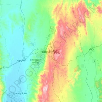
Nombre: Mapa topográfico Taunggyi, altitud, relieve.
Altitud media: 1 151 m
Altitud mínima: 884 m
Altitud máxima: 1 857 m
Haz una donación
Otros mapas topográficos
Haga clic en un mapa para ver su topografía, su altitud y su relieve.
Haz una donación
Pinlaung Township
Myanmar > Shan State > Taunggyi District > Pinlaung Township
Pinlaung Township accounts for the largest area of tea cultivation in southern Shan State. The Tea grown here is of the Assamica cultivar. Tea plantations in the area cover 12,000 acres, with half of the cultivation taking place in the higher elevations of Le Hlaung, 10 miles from Pinlaung. In the Koe Khaung…
Altitud media: 964 m