
Mapa topográfico Shahin Shahr
Mapa interactivo
Haga clic en el mapa para ver la altitud.
Shahin Shahr
The city is among the central mountain ranges of Iran to the east of the Zagros Mountains. It has an altitude of 1662 meters on average with a slope of 16%. It has a dry climate with very little precipitation. The variation in temperature is about 50 degrees Celsius.
Acerca de este mapa
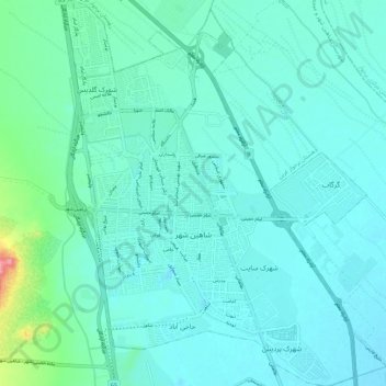
Nombre: Mapa topográfico Shahin Shahr, altitud, relieve.
Altitud media: 1 601 m
Altitud mínima: 1 583 m
Altitud máxima: 1 709 m