
Mapa topográfico Osterdock
Mapa interactivo
Haga clic en el mapa para ver la altitud.
Acerca de este mapa
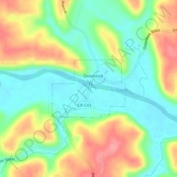
Nombre: Mapa topográfico Osterdock, altitud, relieve.
Lugar: Osterdock, Clayton County, Iowa, United States (42.72740 -91.16704 42.73628 -91.15182)
Altitud media: 227 m
Altitud mínima: 189 m
Altitud máxima: 281 m
Otros mapas topográficos
Haga clic en un mapa para ver su topografía, su altitud y su relieve.
Edgewood
United States > Iowa > Clayton County
Edgewood, Clayton County, Iowa, United States
Altitud media: 352 m
Guttenberg
United States > Iowa > Clayton County
Guttenberg, Clayton County, Iowa, United States
Altitud media: 218 m
McGregor
United States > Iowa > Clayton County > McGregor
McGregor, Clayton County, Iowa, United States
Altitud media: 249 m